The development of the simulator that will be implemented can be classified in two phases. The first phase is the development of a simulator, capable for the investigation of the typical handover procedure.
The second phase will include the implementation of the LAH algorithm that will consider the location of the user. Simulations that will be carried out during phase two should show the increased network stability that results from the enhanced handover algorithm. The simulation can also include the Location Update procedure, which increases the signaling overhead significantly. There are two simulation scenarios, according to the location server that will be used:
- Very fast and accurate positioning systems for positioning all users
- Positioning systems with less computational capabilities
In case of (i) we can make use of the information from the location server (LS) without any problems. In case of (ii) either we should assume an “on-demand” tracing of the user or use of MGIS stored data for enhancement of HO-performance.
Since MGIS has information about the network performance, e.g. call-drop rate, by initializing the network maps it is possible to define critical areas. The critical areas will be the places where the call drop rate is higher than normal and around the borders of each cell, i.e. the places, where the handover procedure is initiated.
We imagine LAH also as an abstract element that performs management based on the position of the user. This can be evaluation of monitoring information or LS-data.
This scenario can be described from the following data:
- Simulated area
- Propagation model
- Area description
- HO reasons: RXLEV, power budget, RXQUAL
- BTS parameters: Cell ID, LAC, BCCH frequency (ARFCN), BSIC, Cell reselection hysteresis, HO threshold (RXLEV, RXQUAL), adjacent cells
A very important procedure for simulations is the measurement report. The measurement report is normally submitted over SACCH channel. By counting the number of reports we can make statistics about the traffic congestion. For simulation environment, prediction maps can be later used during the simulation, which are based on real morphological data.
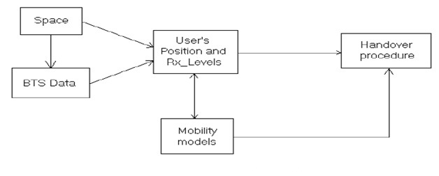
The primary concept, which has to be implemented and will act as a primary layer for all the other modules in the project, is the simulated space of radio coverage. It will host the BTSs and will allow us tracking down users, while they move around. Graphical display capabilities will be also available for the visualization of the LAH algorithm.
After representing the space and initializing the position of a called or calling terminal, we must use a model of mobility, according to the environment, together with an appropriate traffic model. These models will show how the user is moving, duration and start point of calls, etc. By having knowledge of the starting position of the user and the way that he is going to move, we could avoid extra handover requests, especially in situations of moving by the cell’s border (ping-pong problem).
Figure shows a first impression of the simulator’s structure:
The work described in this paper proves that network parameters, coming from position location of mobile terminal will play a significant role for the improvement of the handover procedure. The LAH Algorithm will show the importance of MGIS & LS for the handover improvement..